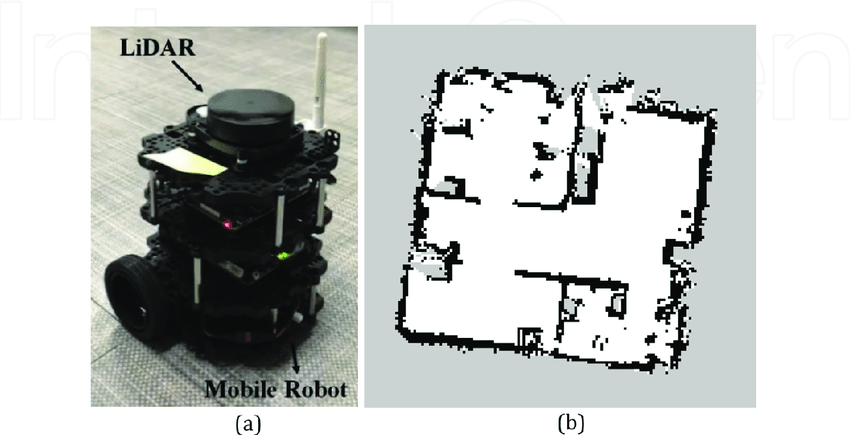
LiDAR Sensor
What is LiDAR?
LiDAR (Light Detection and Ranging) is a remote sensing technology that uses laser light to measure distances between the sensor and objects on the ground. By emitting rapid pulses of laser light and measuring the time it takes for each pulse to bounce back, LiDAR creates detailed 3D maps of the environment. This technology is highly accurate and can capture complex spatial information, making it invaluable in various fields, including robotics, geography, and environmental monitoring.

Key Features of LiDAR:
-
High Precision: LiDAR provides highly accurate distance measurements, often within a few centimeters, allowing for precise mapping and object detection.
-
Rapid Data Collection: LiDAR systems can capture millions of data points per second, enabling the quick generation of detailed 3D models of the environment.
-
Penetration Capabilities: LiDAR can penetrate through vegetation, making it effective for mapping forested areas and determining terrain beneath foliage.
-
Versatile Applications: Used in diverse fields such as autonomous vehicles, topographic mapping, forestry, and urban planning, LiDAR has a wide range of applications.
LiDAR in Robotics

How LiDAR is Used in Robotics
LiDAR sensors play a crucial role in robotics, particularly in the development of autonomous systems. Here’s a breakdown of how LiDAR contributes to robotic applications:
1. Environment Mapping
LiDAR allows robots to create detailed 3D maps of their surroundings. This capability is essential for navigation and path planning, enabling robots to understand their environment and identify obstacles. The high-resolution mapping helps robots navigate complex terrains safely and efficiently.
2. Object Detection and Recognition
LiDAR sensors provide accurate distance measurements, allowing robots to detect and recognize objects within their environment. By analyzing the point cloud data generated by the LiDAR, robots can identify various objects, such as people, vehicles, and obstacles, enhancing their situational awareness.
3. Autonomous Navigation
LiDAR is integral to the navigation systems of autonomous robots and vehicles. By continuously scanning the environment, LiDAR helps robots determine their position relative to obstacles and map out safe paths. This information is crucial for real-time decision-making and dynamic path planning, allowing robots to adapt to changing conditions.
4. SLAM (Simultaneous Localization and Mapping)
LiDAR sensors are widely used in SLAM algorithms, which enable robots to create maps of unknown environments while simultaneously keeping track of their location. This capability is essential for autonomous navigation in unfamiliar or dynamic settings, allowing robots to operate effectively without pre-existing maps.
5. Safety and Collision Avoidance
In applications like autonomous vehicles and drones, LiDAR enhances safety by providing real-time data on the robot's surroundings. By detecting potential obstacles and hazards, LiDAR enables robots to take evasive actions or stop to avoid collisions, making them safer for both users and the environment.
6. Terrain Analysis
LiDAR can analyze terrain characteristics, such as elevation, slope, and surface features. This information is valuable in robotics applications like agriculture, mining, and construction, where robots must operate in varying terrain conditions. By understanding the terrain, robots can adapt their movement strategies for better efficiency.
7. Enhanced Data Collection
LiDAR sensors are also used in robotic data collection for various applications, such as environmental monitoring and archaeological surveys. Robots equipped with LiDAR can gather extensive data over large areas, providing valuable insights and contributing to research and conservation efforts.
8. Integration with Other Sensors
LiDAR is often used in conjunction with other sensors, such as cameras and IMUs (Inertial Measurement Units), to provide a comprehensive understanding of the environment. This sensor fusion enhances the robot's capabilities, improving performance in complex tasks like navigation, object recognition, and environmental interaction.
9. Applications in Education and Research
LiDAR technology is increasingly used in educational settings to teach students about robotics, remote sensing, and environmental science. By incorporating LiDAR into hands-on projects, students gain practical experience and knowledge of cutting-edge technologies, preparing them for careers in STEM fields.
Conclusion
LiDAR sensors are transformative components in robotics, providing high-resolution mapping, object detection, and real-time navigation capabilities. Their accuracy and versatility make them indispensable for autonomous systems operating in complex environments. As robotics continues to evolve, the integration of LiDAR technology will further enhance the capabilities and safety of robotic applications across various industries.